We've developed a model that can predict bushfires over a week-long period with an accuracy of 91%.
Over the past decade, the frequency of bushfires in Australia has increased. The Forest Fire Danger Index – which measures the frequency and severity of the weather most conducive to fire – has increased dramatically since the 1970s, and particularly in the 1990s and 2000s. This – along with a great deal of other evidence – indicates that a major change in the climate is looming.
In a study published today in Royal Society Open Science, we show that bushfire frequency has increased by 40% over the past five years.
This is part of our work to better predict bushfires using weather information. We developed a model that can predict bushfires over a week-long period with an accuracy of 91%. While we can’t yet use this to predict fires definitively, it is a big step forward in planning for and predicting fires.
There is an urgent need for scientific research that can contribute to Australia’s future bushfire preparedness. The knowledge gained from this research could help save lives and property, underpin effective building codes and help land-management decisions.
Fire forecasting gets smart
We wanted to find bushfire “hotspots” – places where a bushfire might happen in the future based on recent weather patterns. They don’t show that a bushfire will definitely happen, and similarly we need to be careful that people don’t assume a fire won’t happen if there is no hotspot.
To do this we developed a model that combined data on fires (from satellite images) with data on climate, including soil moisture, dry fuel load, wind speed, temperature and humidity.
We are using a machine learning approach to model future bushfire hotspots – in short, a form of artificial intelligence that allows the model to learn on its own. Our model used other forms of learning to produce maps of bushfire hotspots.

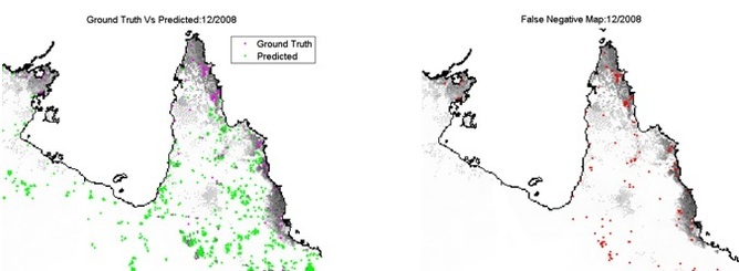
Map showing predicted hotspots (green) and real fires (purple). Red dots show fires not predicted by the model.
Ritaban Dutta
Predicting hotspots
We tested our model by looking at bushfires retrospectively. Our predictions achieved 91% global accuracy. The analysis also indicates that, on a week-by-week basis, the frequency of Australian bushfires, particularly during summer months, has increased by 40% over the past five years.
We conducted extensive research in Australian bushfire history, to make sure the data on the conditions and behaviour of 36 major fires were correct.
Two types of Australian vegetation are prone to fire: grasslands and forests. We found that our model could predict both.
Fighting fires
Although new technologies are being developed to manage the growing number of unplanned bushfires in Australia, we do not have, and are never likely to have, a way to avert natural fire disasters.
The recent history of Australian bushfires indicates that the most effective way to save lives is early planned evacuation, combined with timely advice and alerts to the people potentially at risk.
Early estimation of the likely frequency of future bushfires, and accurate hot-spot estimation of the locations most likely to be affected could provide great support to land managers, and assist in reducing the damage caused.
But as yet, our system exists only as a research model. Its impact and effectiveness could only be fully evaluated if a real system were implemented as a decision support tool for land managers and emergency services, to accurately forecast the most likely bushfire hot spots, at a detailed and fine-grained resolution and a timely scale.
![]()
Ritaban Dutta, Senior Research Scientist and Research Project Leader, Data61, CSIRO
This article was originally published on The Conversation. Read the original article.


Pingback: Disaster response starts at home…and more | resilience reporter
Pingback: Recent St Louis flooding made worse by human changes to landscape…and more | resilience reporter
11th February 2016 at 4:48 pm
Could you show the false positives as well please?