We're working with NASA to uncover the mysteries of Great Barrier Reef.
Update 14/09/2016
NASA has landed on the Great Barrier Reef!!
The Coral Reef Airborne Laboratory (CORAL) Mission is in full swing, with the specially modified Gulfstream airplane now taking up residence in Cairns – when it’s not flying!
Last week our researchers Janet Anstee, Dr Nagur Cherukuru and Dr Hannelie Botha returned from in-water validation activities in the Torres Strait. Battling three metre seas, 25 knot winds and some cheeky baby reef sharks, the team collected water samples and optical data to tell us about the type of sediment, dissolved carbon and dissolved organic matter within the water.
Later this month researchers will collect more data while on board the blue-water research vessel, Investigator, which is operated by the our Marine National Facility. The data we collect will help validate and calibrate the information collected by NASA’s plane and add to data collected by the broader CORAL team. The mission is set to be completed by the end of September and once the data has been processed it will be made publicly available to help inform future research on the reef.
We’ve been working with NASA for over 50 years, and in that time we have achieved some amazing things. Together, we watched the first steps on the Moon, we run the NASA Deep space Communications Complex and we uncovered the true face of Pluto – now we’re working to uncover the mysteries of a location much closer to home: the Great Barrier Reef.
In October, six sections of the Great Barrier Reef and some Coral Sea reserves will be surveyed like never before. And it’s not just Australia’s national treasures that we’ll be exploring, the project will also survey coral reefs in Florida, Hawaii, Palau and the Mariana Islands as part of a three-year international expedition.
Last week, senior NASA staff are in Canberra to consult with our Earth Observation Informatics, Future Science Platform, Land and Water, Ocean and Atmosphere teams, and other interested stakeholders. Together we discussed the best way to get up to date information on the condition of this massive reef.
Diver and coral reef
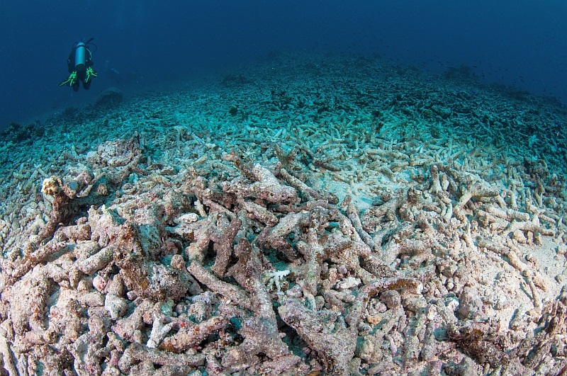
This Acropora field in Fiji was exposed to multiple impacts including a crown-of-thorns outbreak and cyclone damage. Image credit – Matt Curnock 2012
Coral reefs are home to a quarter of the fish species in the ocean, they protect our shores from battering storms and provide food for millions of people. Yet what we know about them is just a drop in the ocean.
To date, coral reef records have been taken manually from someone diving the reef, or through aerial surveys using spotters and photographs. In previous cases, satellites such as Landsat or some small scale airborne image spectrometer trials have been used. We have even sent unmanned underwater vehicles onto the reef in an innovative application of robotics.
The challenge of collating data on the Great Barrier Reef is that it is bigger than Victoria and Tasmania combined, and efforts to survey it have seemed laborious and insufficient.
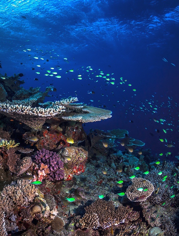
Healthy coral reef slope in the northern Great Barrier Reef. © Matt Curnock 2013
All that is set to change with new game-changing technology created at NASA’s Jet Propulsion Laboratory (NASA-JPL) that measures reef conditions using an airborne imaging spectrometer dedicated to aquatic environments installed in an aeroplane. The data that the airborne laboratory collects will be used in conjunction with in-water measurements taken by our scientists and US colleagues to provide a more detailed spatial analysis of the Great Barrier Reef than has ever been available before.
Janet Anstee is part of the field validation team and said a lot of innovative research has gone into in-situ reef surveys in the past, but the added technology of the aerial digital spectrometry imagery will take coral reef research to a new level.
“The ability to integrate high resolution remote sensing allows us to scale up the information in a way that is more relevant for the ecosystem,” she said.
This is the first dedicated aquatic environment imaging spectrometer ever flown in Australia. It is also a pre-orbital mission meaning that, if successful, this could lead to a space based imaging spectrometer in the future.
Drawn image of a jet scanning images of a coral reef.
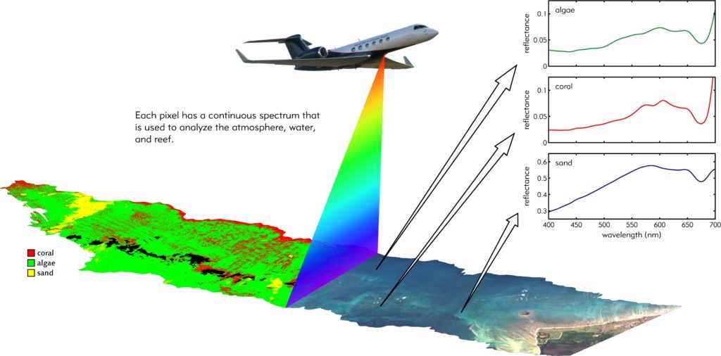
NASA’s game changing technology acquires airborne spectral image data using the Portable Remote Imaging Spectrometer (PRISM) instrument installed in an aeroplane. This will record the spectra of light reflected upward toward the instrument from the ocean below. Its very high spectral resolution is then used to identify reef composition. Image credit – NASA/JPL-Caltech
Climate Change and coral reefs
This comes at a critical time for marine research. Last year, the annually-averaged temperature for ocean surfaces around the world was 0.74°C higher than the 20th century average, easily breaking the previous record of 2014 by 0.11°C.
We know that coral reefs are especially vulnerable to warming ocean temperatures. Increases in water temperature by one degree for one month can trigger a coral bleaching event.
Coral reefs are also threatened by pollution and changes in sea levels sooner than other ecosystems.
“Reefs act as a sentinel to what’s going on with climate change. We are seeing dramatic impacts on reef environments as a result of increasing temperatures, and long term impacts on the viability of places like the Great Barrier Reef,” said Janet.
A main objective of the expedition is to build a better understanding of coral reef health and anthropogenic influences, while arming scientists with the tools to accurately model these impacts and mitigate against changes.
Significant scientific methodology has already gone into creating models that show what is happening in the reef ecosystem, and how it is changing. The NASA mission will provide the data needed to calibrate these models.
The expedition will inform on key marine health indicators such as benthic cover of coral, algae and sand cover, bio-optical properties of the water, primary productivity and calcification.
“We want to know how global coral ecosystems are changing, what the coral cover is and how the biogeochemcical cycles respond to environmental changes as a consequence of climate change and increased activities in those regions, says Janet.
