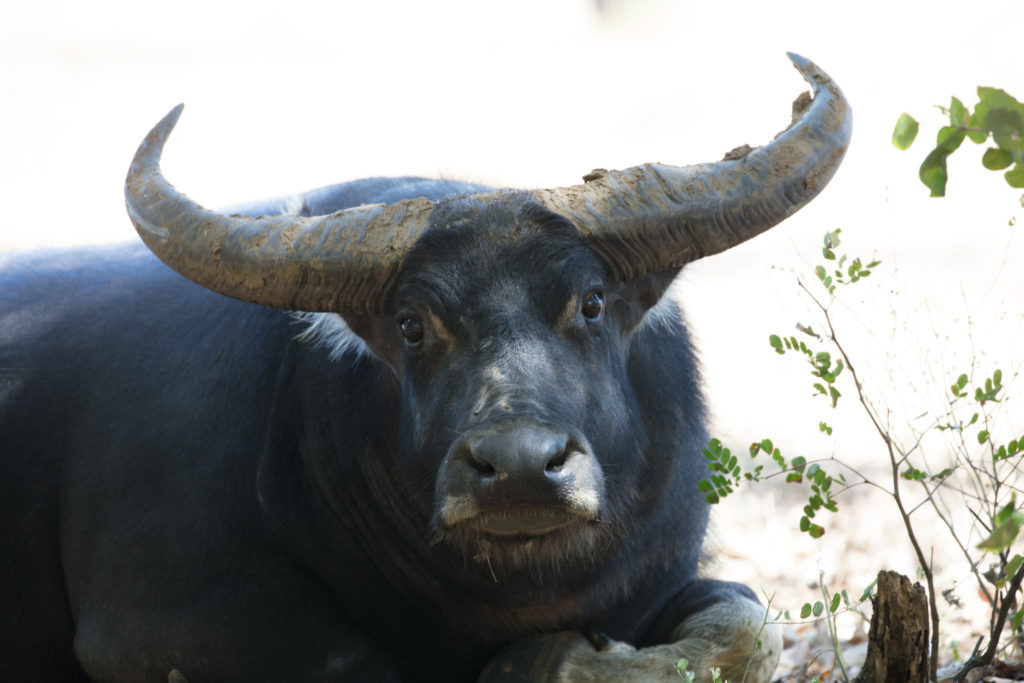
Water buffalo in Northern Australia. IMAGE: Peter Cooke
When talking about Northern Australia, it’s easy to let the superlatives flow. Some of the world’s most remote and vast landscapes. Home to unique cultures that have existed for thousands of years. Ecosystems not found anywhere else in the world.
The distances are also incredible. It’s a 4516km drive along Northern Australia’s southern boundary. A long arc stretching from Karratha in Western Australia to Rockhampton in Queensland. Take that drive in Europe and you’d make it from Paris to Moscow, then most of the way back again.
Traditional Owners manage much of these seemingly endless tracts of land. All up, they manage an area larger than South Australia and Victoria combined.
Stark, serene, and environmentally sensitive. It’s also the site of a decades’ long invasion by four-hooved interlopers: water buffalo and unmanaged cattle. They’re devastating local ecosystems, damaging sacred sites, and causing a massive financial strain on communities.
Australia’s bovine menace
Water buffalo were introduced to Northern Australia more than a hundred years ago. Left to their own devices, they’ve spread across the Northern Territory’s floodplains. There’s now an estimated population of more than 120,000 buffalo.
Unmanaged cattle have spread even further from their original cattle stations across Northern Australia. Their numbers are estimated to reach into the hundreds of thousands.
Currently, these chaotic quadrupeds overgraze native vegetation, cause erosion, and destroy rivers and wetlands. They damage biodiversity, cultural assets, water resources, and ground cover. They are also expensive and difficult to manage.
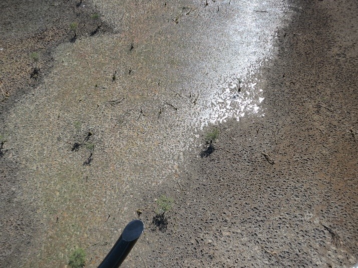
Environmental damage caused by water buffalo.
Tracking buffalo by satellite
We’re part of a consortium looking to change that. This work is funded by the Department of Agriculture, Water and the Environment under the National Landcare Program – Smart Farming Partnerships initiative.
The $4 million, 3.5 year project will develop leading-edge satellite GPS tracking ear tags and software.
But how do you achieve that across Northern Australia’s harsh, sparse and remote landscape? We’ll need a large satellite herd tracking program, unprecedented spatial data sets, innovative data-driven planning tools, and training in best-practice ethical mustering and handling methods.
In short, we’re going to need a pretty amazing team.
Consortium assemble!
Thankfully we’ve found that in the form of Northern Australia’s two premier universities, a French satellite company, four Indigenous organisations, and Australia’s national science agency (us!).
We’re working with James Cook University, Charles Darwin University, and Kineis to develop leading-edge satellite GPS tracking ear tags and software.
At the same time, North Australian Indigenous Land and Sea Management Alliance Ltd (NAILSMA) will create ethical animal handling standards. They will also train our on-ground partners – Mimal Land Management Aboriginal Corporation, Aak Puul Ngantam Ltd, and South Cape York Catchments Inc – in their use.
One thousand buffalo and cattle will then be tagged and tracked by satellite across some of Australia’s most remote locations. These are the Arafura swamp catchment in Arnhem Land and the Upper Normanby and Archer River catchments on Cape York Peninsula.
Our on-ground partners are the Traditional Owners of these test sites and will lead activities on their land. This ensures local governance and cultural rules drives the outcomes.

Kineis Nanosatellite. Planned for launch in 2022 ©David Ducros
Going global
Eventually, the project will place cutting edge satellite technology, machine learning, and analytics into the hands of Traditional Owners.
The system will give Indigenous communities real-time, geographically accurate, predictions of herd density, how accessible they are, and how much it would cost to transport them. It will let communities manage herds, increase economic and environmental benefits, protect their environment, and guard cultural sites.
It is hoped the technology will foster Indigenous economic development and increase opportunities in areas with chronic under-employment. The sale of ethically sourced meats, for instance, is a developing and high-value market. Creating best practice standards as part of this project could lead to a new industry, new revenue and more jobs.
Better management of wild buffalo and uncontrolled cattle expects to help biodiversity. This is a result of reducing grazing pressure and improving water quality. This aids the recovery of native flora and fauna. Ultimately, this will result in a more resilient landscape better equipped to cope with threats such as fire, invasive species, and climate change.

29th May 2020 at 1:33 pm
Can you adapt this technology to managing feral camels; pigs and cats in desert areas?( I appreciate cats do not travel in herds)
29th May 2020 at 1:42 pm
Hi Tom,
It potentially could be for larger animals like feral camels and pigs. Currently, though the focus of this project is helping manage wild buffalo and unmanaged cattle in Northern Australia.
Kind regards,
Kashmi
Team CSIRO
28th May 2020 at 8:19 am
I seem to recall there was a water buffalo eradication program in place in Northern Australia some 20 years or so ago?
The idea of herd management assumes herd size control by slaughtering and, as a result, meat processing. Where would such facility be available?
Yvan Dufour
27th May 2020 at 5:45 pm
Is this a pilot program that will be greatly expanded? Because one thousand animals tagged and managed out of 120,000 buffalo and hundreds of thousands of feral cattle in Northern Australia is not going to help much on “reducing grazing pressure and improving water quality. This aids the recovery of native flora and fauna. Ultimately, this will result in a more resilient landscape better equipped to cope with threats such as fire, invasive species, and climate change.”
27th May 2020 at 10:26 am
An excellent paper and a technique with wide potential application. Thank you.
27th May 2020 at 9:28 am
If they are such a menace for several reasons, wouldn’t culling, or to use plain language, mass killing, be more effective?
27th May 2020 at 11:17 am
Hi Don, thanks for your message. By locating and managing the cattle and water buffalo, instead of culling them, they can potentially be turned into a source of income for indigenous communities.
This project will help traditional owners develop the skills, practices and technology needed to manage herds on their land.
Kind regards
Kashmi
Team CSIRO