Our Centre of Excellence for 3D Mineral Mapping was announced Australian Mining’s ‘Explorer of the Year’ last night.
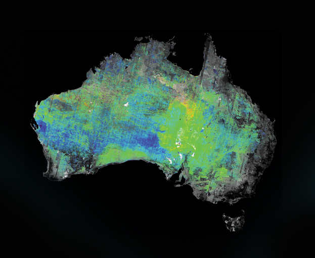
The team, led by Dr Tom Cudahy, developed the world’s first suite of maps that show the mineral composition of the surface of an entire continent. The maps are helping mining companies increase the efficiency and viability of their exploration efforts.
An Australian ASTER map showing composition of aluminium clays
They were generated from a ten-year archive of raw Advanced Spaceborne Thermal Emission and Reflection (ASTER) data collected by NASA and the Japanese Government’s Japan Space Systems.
Already, they have led to a golden discovery by Kentor Gold, a mid-tier gold company with advanced projects in Australia and the Kyrgyz Republic.
After the ASTER maps revealed some previously unknown ‘areas of interest’ Kentor’s senior project manager Rudy Lennartz scoped an area of about one square kilometre 350km outside of Alice Springs. Spot readings showed what Mr Lennartz describes as ‘a lot of good copper, a couple of good gold assays and possibly lead and silver’.
Kentor Gold managing director, Simon Milroys says the ASTER map project is a great example of CSIRO working together with industry.
‘The ASTER maps are a very valuable exploration resource,’ he says.
It looks like Australian Mining agrees too.
The nearly 20-year ASTER project involved CSIRO, Geosciences Australia, NASA, the US Geological Survey, Japan Space Systems, National Computing Infrastructure, the state and territory geological suveys, Auscope Grid and numerous exploration and mining companies.
Read more about the ASTER maps in the next issue of our magazine resourceful, due out 13 November.


7th November 2012 at 3:14 pm
Go Tom!
A well deserved level of recognition.
7th November 2012 at 1:59 pm
Congratulations, Tom!
3rd November 2012 at 8:30 am
Scary news. Does it have any other purpose than to find minerals?
6th November 2012 at 12:38 pm
In addition to their value for resource exploration, these mineral maps provide new information that can help address increasing global environmental challenges. For example, the progression of desertification is accurately mapped by the ASTER silica product which delineates the current extent of sandy deserts across Australia. Dust management is helped using the ASTER clay content map which highlights large concentrations of exposed clay in regions such as the Lake Eyre Basin, which is a known source of dust in recent storms. The associated clay and iron oxide composition maps enable fingerprinting more precisely the geographic source of eroded dust. The distribution of ferrous-bearing silicates, like chlorite, is restricted to rarer exposures across the country, such as greenstones in the Pilbara Craton, which are being stripped and deposited in the neighbouring marine environment. The importance of ferrous silicates is now being recognised as a key catalyst for marine biogenic activity and its impact on carbon dioxide levels. Minerals are also fundamental to soils and their agricultural productivity, water retention and permeability/runoff.