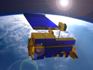
Satellites are used for a number of purposes military observation, communication, navigation, weather and research. We have used satellite data to create the ASTER maps, a suite of maps that show the different minerals on the surface of the Australian continent.

These maps are particularly useful to mineral explorers because it will give them a good idea of where the minerals are. They can then target their drilling programs better, giving them a greater chance of finding valuable resources.
To create the maps we accessed a ten-year old archive of raw Advanced Spaceborne Thermal Emission and Reflection (ASTER) satellite data from NASA and from Japan’s Earth Remote Sensing and Data Applications Center. We designed the software that transformed the data to make the maps with some help from Geoscience Australia and the national and state geological surveys.
This technology, by increasing the efficiency of exploration, could save the minerals industry millions of dollars in exploration costs. However, the ASTER maps won’t just be used for mineral exploration; they also include soil and environmental mapping. Allowing us to use images from the sky to explore what lies beneath our feet.


6th May 2013 at 9:44 pm
So you are looking to rid your girl of these unwanted stalkers when you are drawn to Willow Creek’s Black Mirror Castle. I won’t spoil your surprises and give away any more details.
Play games all night long in keeping with the twenties
theme such as various card games and crossword puzzles.