By Matthew Paget
Striking images of smoke plumes and scarring from the bushfires that swept south eastern Australia in January 2013 have been put together from selected NASA satellite imagery by CSIRO and partners from the Terrestrial Ecosystem Research Network (TERN).
To help study and manage the impact of the fires, the latest cloud-free images of the evolution of the recent bushfires have been assembled from NASA’s Earth Observing System Data and Information System satellite imagery.
When combined with ground data and knowledge held by CSIRO and its research partners, such images taken over time, can be used to help study the extent of burn scarring, as well as vegetation recovery after the fires have passed. This is one example of the sort of information that the research team can provide to help improve the understanding and management of the landscape including for: vegetation and fire issues, agricultural productivity, water and flood management, carbon accounting, fertiliser and resource use studies.
Fires burning in Tasmania – 5 January 2013
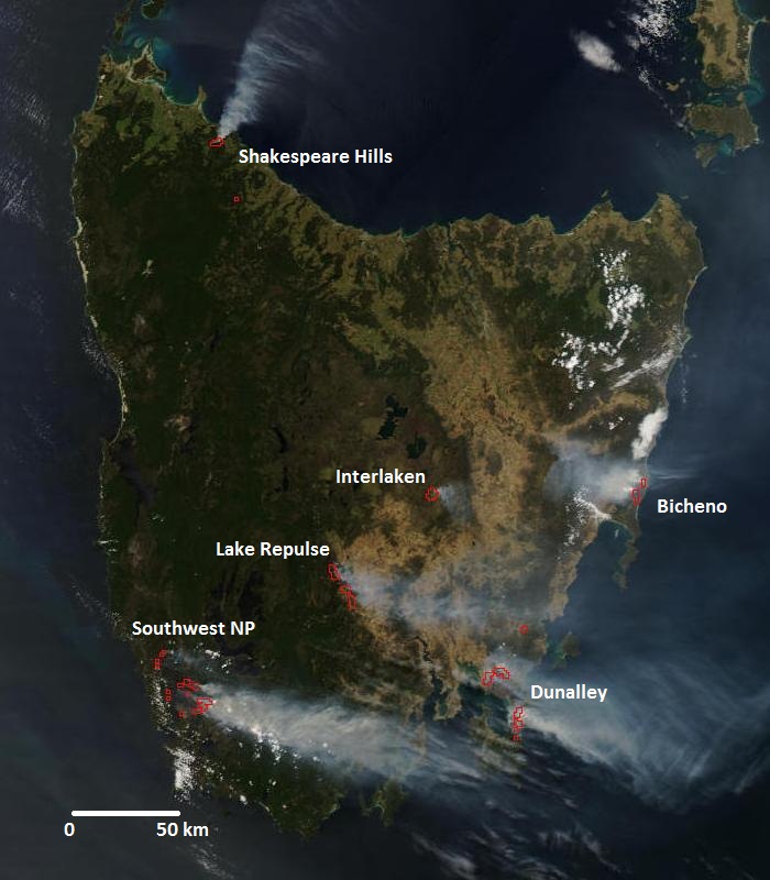
Two images from the same satellite pass on 5 January 2013. (a) Visible (true colour) image shows numerous smoke plumes from six major fires across Tasmania. (b) The enhanced (bands 7-2-1) image highlights the extent of burn scarring. Extensive scarring (brown patches on the landscape) can be seen for both the Dunalley and Southwest National Park bushfires. At the time of this satellite pass, the Dunalley fire had passed through Dunalley from the north and continued to burn both to the north near Forcett and to the south on to the Tasman Peninsular.
Source: NASA near real time (orbit swath) images. MODIS/Aqua, 5 Jan 2013 0425 UTC (approx. 1525 local).
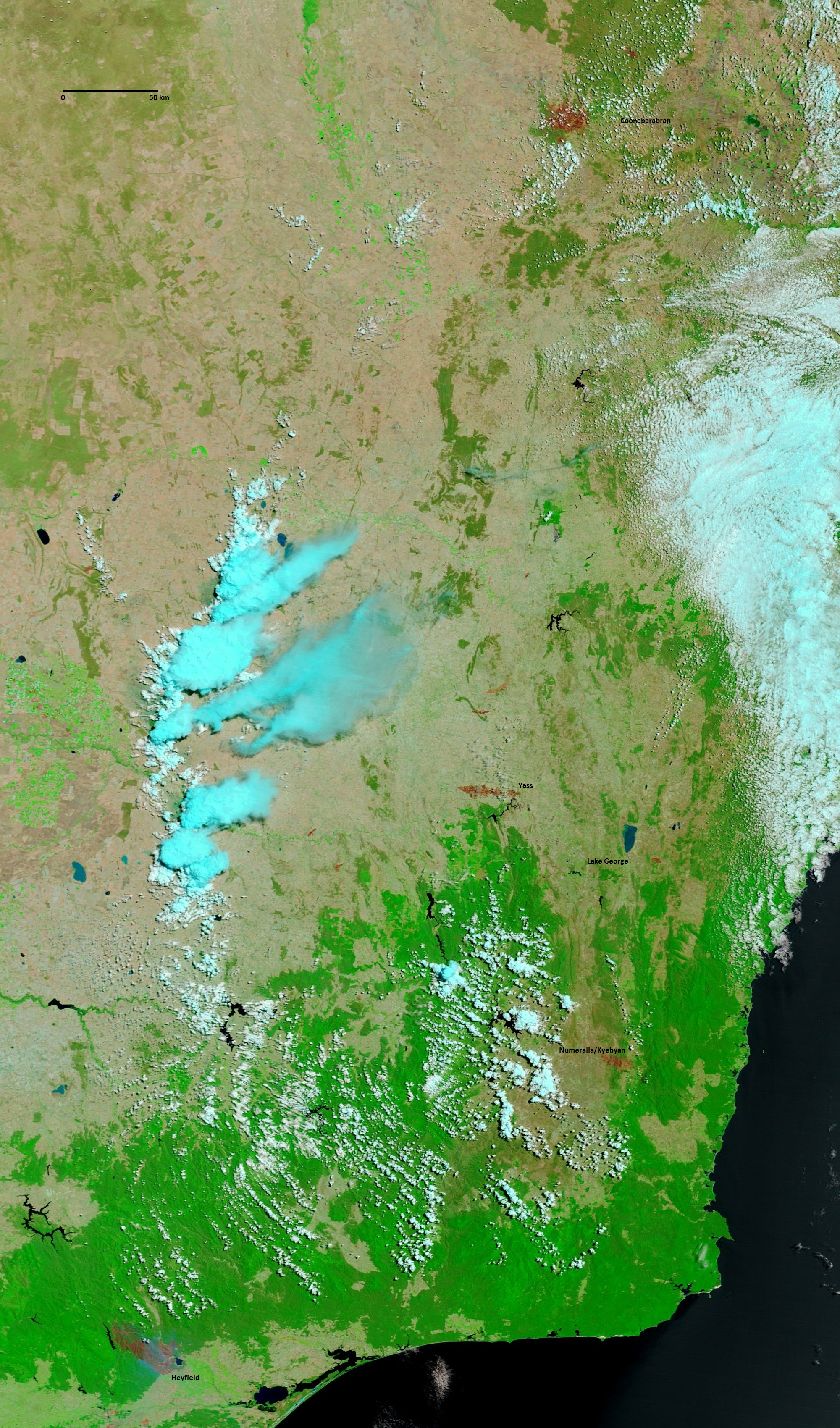
Southeast NSW – 9 January 2013
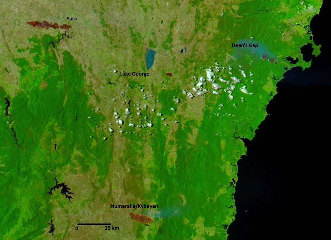
This image (bands 7-2-1) shows the extent of burn scarring on 9 January 2013. Large burn scarring areas (brown patches on the landscape) are visible for the Yass and Numeralla/Kybeyan fires. Smaller scars are visible for Dean’s Gap near Jervis Bay and a small fire to the east of Lake George. Together with ground-truthing, images like these can be used to assess the extent and, to some degree, the severity of individual bushfires.
Source: NASA near real time (MODIS subsets) images. Georectified composites of multiple satellite passes for MODIS/Terra (7 Jan 2013) and MODIS/Aqua (9 Jan 2013).
Coonabarabran morning and afternoon smoke plumes – 14 January 2013
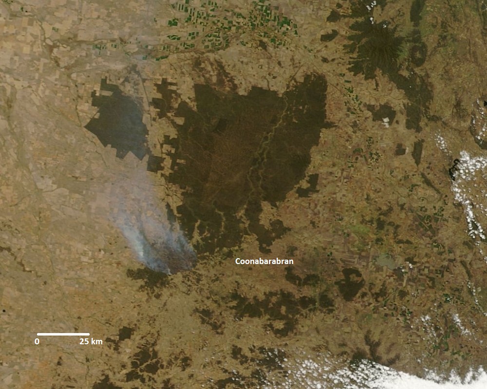
Two images (true colour) showing the growth of the Coonabarabran fire as evidenced by a larger smoke plume between the (a) morning and the (b) afternoon of 14 January 2013.
Source: NASA near real time (MODIS subsets) images. Georectified composites of multiple satellite passes for MODIS/Terra (morning) and MODIS/Aqua (afternoon).
Large smoke plume from Gippsland fire – 18 January 2013
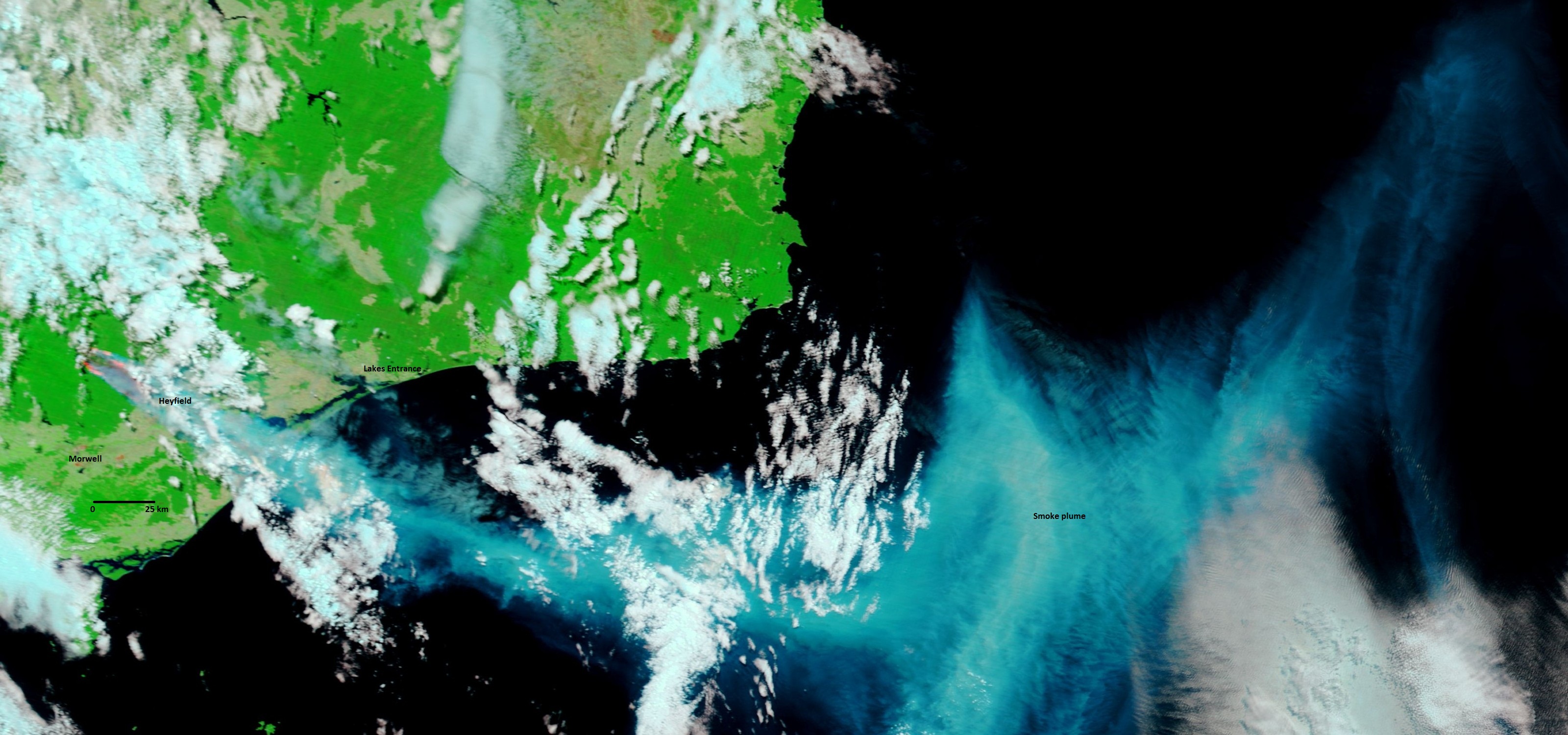
Bands 7-2-1 image of eastern Victoria on 18 January 2013. In this case the smoke plume (blue) from the Gippsland fire contrasts with the cloud and the plume extends well into the Tasman Sea. The image shows the extent of the fire and burnt area from near Heyfield extending to the northwest into the Baw Baw National Park.
Source: NASA near real time (MODIS subsets) images. Georectified composites of multiple satellite passes for MODIS/Terra.
Victorian and NSW burn scars – 21 January 2013
Bands 7-2-1 image over eastern Victoria and NSW on a relatively cloud-free day in which the burn scars from the major fires of the previoust two weeks can be seen.
Source: NASA near real time (MODIS subsets) images. Georectified composites of multiple satellite passes for MODIS/Terra.
Information about the images
Images were accessed from NASA’s Earth Observing System Data and Information System (EOSDIS), MODIS Subsets and MODIS Near Real Time (Orbit Swath) Images browse services. Images were created from MODIS bands 1-4-3 (true colour) and bands 7-2-1 (burn scarring). Bands 7-2-1 discriminate burnt area features as red-brown patches on the landscape and have enhanced water contrast (blue) and vegetation (green) compared to true colour images. The images shown here have been cropped to reduce file size and highlight smoke plumes and burn scars of interest. Annotations give an approximate guide to nearby towns and the scale of the images.
Burn scarring and vegetation loss
CSIRO and TERN/AusCover coordinate routine (but not near real time) processing of satellite data to provide a range of products that can help agencies assess burn scarring and vegetation loss after bushfires. Such products include monthly burn date and area, fortnightly vegetation fractional cover and vegetation indices, and grassland curing indices. These products will be available from early March 2013 to assist with analysis of the recent fires in south eastern Australia.
Near real time satellite data can be browsed and downloaded from NASA websites. In Australia these data and services are provided and used operationally by the Bureau of Meteorology, Geoscience Australia, the state fire agencies and their state government departments to provide near real-time assessments of burn scarring and vegetation loss due to bushfires. The Sentinel Hotspots system for tracking bushfires by satellite, co-developed by some of the original members of the AusCover team in CSIRO in 2003 and now managed by Geoscience Australia, is an example of near real time data services in Australia.
TERN/AusCover has brought together remote sensing experts and practitioners from CSIRO, universities, Geoscience Australia, the Bureau of Meteorology and state government departments to improve and coordinate systems and methods for managing Australia’s satellite remote sensing resources and to produce best available and validated remote sensing products relevant to the terrestrial environment. AusCover supports a broad range of landscape remote sensing work related to agricultural, land use, vegetation change, carbon accounting studies and flooding.
Further information:
Remote sensing fire products : http://data.auscover.org.au/xwiki/bin/view/Outreach/brisbane-20121116.
CSIRO’s Bushfire research: https://www.csiro.au/en/Outcomes/Environment/Bushfires.aspx
TERN / AusCover: http://data.auscover.org.au
Contact:
Dr Alex Held
Director AusCover Facility TERN
CSIRO Marine and Atmospheric Research
P: 02 6246 5718
E: Alex.Held@csiro.au
