A new tool is equipping the mining industry with a way to reduce risk when faced with extreme weather offering mines a more comprehensive and realistic way of reducing risks associated with wild weather.
The tool known as CRATER (Climate Related Adaptation from Terrain Evaluation Results) was tested at a mine in a flood-prone part of Queensland’s coal-rich Bowen Basin and will be used before each wet season to identify vulnerabilities.
The pilot project completed in April was funded by the Australian Coal Association Research Program (ACARP) and CSIRO. Additional mines in the region have been offered to host a wider project.
CRATER’s main benefit is its holistic nature. Traditional risk models identify potential hazards but CRATER also takes users through the process of finding potential solutions and choosing which is the most appropriate for the mine at that time. This helps to minimise the risks posed by extreme climate events, ultimately helping mines to protect lives, save money and continue production.
The leader of the CRATER project is Dr Jane Hodgkinson, a geologist and data analyst at CSIRO.
Dr Hodgkinson was already running a wider project looking at the impact of climate change, and weather extremes in the mining industry, when the big Queensland floods hit in January 2011.
“I was working with a geographic information system (GIS ) specialist from the Queensland Government, Dr Micaela Grigorescu, and I began to realise that GIS could play a big role in mitigating minesite risks connected to an ever-changing climate,” she says.
“CRATER is not a piece of software, but a series of steps that enables mine managers to weigh up the options. It won’t replace what they already do – it will be complementary.”
Dr Grigorescu says that despite its great capabilities, GIS is not widely employed to its full potential in this particular field.
“In many activities where spatial data is available, GIS is still used only for basic manipulation and visualisation of geo-referenced datasets,” she says.
“Regardless of the issues being modelled or the amount of available data, the main goal of any GIS –assisted assessment is to provide support for making spatial decisions.”
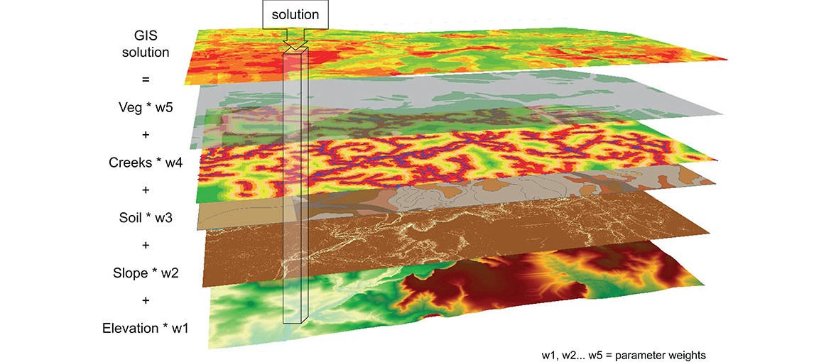
Dr Grigorescu explains that GIS offers the possibility of manipulating and assessing a wide range of information such as landscape character (elevation, slope and stream positions), the types of soil and the types of vegetation cover.
“For CRATER, all of these layers of information are assessed and given a ‘weighting’, depending on their influence on flooding,” she says.
“In some areas it may be that the slope angle is more important and has a greater impact, whereas in other areas it may be the vegetation. You can add more information layers to get the most comprehensive assessment.
“Also CRATER is not just based on historical data and as such, is less hypothetical. It can include human experiences too (what people actually saw during a flood, for example), which helps us to paint a more detailed, accurate and authentic picture.”
Where modelling might come up with a view of a mine’s hotspots, CRATER offers the mine a more comprehensive three step approach that involves GIS modelling, a fault tree analysis and a five capitals analysis.
“This approach guides a mine through the process of deciding where to spend say, its next two million dollars, or where best to deploy its employees,” Dr Hodgkinson says.
The wealth of GIS results (step 1) allows the CRATER team to produce a traffic light map with the most vulnerable areas – the hotspots – marked red and orange and areas of least concern marked green.
This map is overlaid with the mine’s unique infrastructure to ascertain the most vulnerable buildings, roads, mine pits and underground entries.
“We also produced a fault tree model (step 2), which provides decision-makers with information on how the risk management team arrived at the potential counter-measure options to minimise risks,” Dr Hodgkinson says.
“And there’s a five capitals analysis diagram (step 3), which assesses essential resources such as human capital and financial capital and explains why the final recommended counter measure option is the best one for the mine at that time.
“You can add new layers and new scenarios to CRATER, allowing seasonal and ‘what if’ scenarios to be assessed.”
CSIRO sees the initial interest from the Bowen Basin mine as a step forward in assisting the industry to adapt to climate change.
Dr Barton Loechel, a social scientist at CSIRO working with Dr Hodgkinson on the issue of mining adaptation to climate change says, “With the dramatic flood events of recent years and the increased severity of drought, heatwaves, bushfires and sea level rise that affects ports and customer supply, the Australian mining industry needs to be able to seriously look at risks to its operations from climate change”.
“While a few companies have started undertaking formal risk analyses, a national survey that the CSIRO team conducted (recently published in the journal Climatic Change) showed only about 13 per cent of companies had undertaken any work in this area,” he says.
The question of using the ‘force majeure’ liability clause to protect mining companies from the negative effects of extreme climate events remains. Force majeure relies partly on an event being unpredictable but the more these events happen the harder that may be to argue.
“Force majeure for extreme weather events will probably always be necessary at some level given the immense impacts these events can have across often dispersed supply chains,” Dr Loechel says.
“However, given past events and the readily available information on the likely effects of climate change on intense rainfall events, customers could reasonably expect their suppliers to take proportionate action to ensure reliability of supply.”
