UPDATE 04/09/15: Here is our latest analysis on the trajectories of the Global Drifter Program drifters.
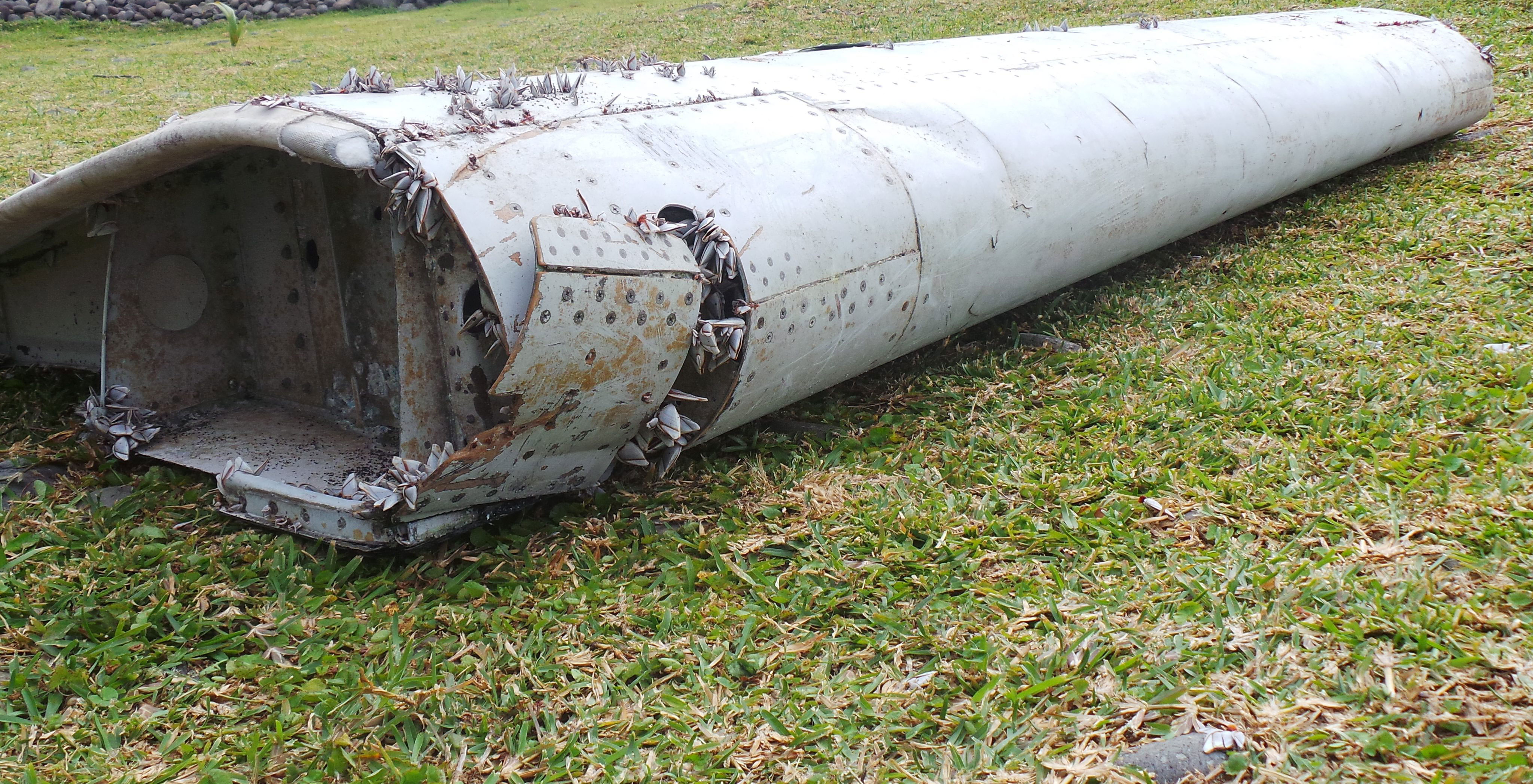
The flaperon discovered on La Reunion. Image: The Independent.co.uk
The tragic mystery surrounding the disappearance of Malaysia Airlines flight MH370 has again attracted international media attention, with the discovery of part of a Boeing 777 wing, known as a flaperon, on La Réunion in the Indian Ocean. The flaperon is thought to be associated with the aircraft that is believed to have disappeared in the south-east Indian Ocean.
You may remember we were involved in the initial search of MH370 over a year ago, providing advice to the Australian Maritime Safety Authority on the potential drift of buoyant items in the ocean from the suspected crash area.
With the discovery of the 777 flaperon on La Réunion, we have again been called on for our expert ocean modelling advice. And it appears our original predictions may have been on the money.
The most recent drift modelling indicates that the overall drift of most debris in the months to July 2015 is likely to have been north and then west away from the accident site, indeed as far west as La Réunion. The finding of a flaperon on La Réunion does therefore match up with the calculations that place the crash site in the present area being searched by the Australian Transport Safety Bureau (ATSB).
Background
Following our contribution to the initial search, in November 2014 the ATSB asked us to perform drift modelling based on the revised search area defined in the MH370 – Flight Path Analysis Update report. This modelling indicated that there was a very low probability that any debris from MH370 would have made landfall in the east Indian ocean at that time. Since then, we’ve made further refinements to our drift modelling. Our most recent models have extended the drift area to include the western Indian Ocean. We have also included an approximation of the effect of waves in addition to that of the wind and surface currents.
This figure shows indicative drift from the search area as at 30 July 2015 produced from our latest modelling:
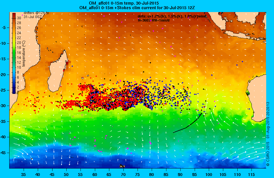
Blue, black and red dots simulate items blown by wind (in addition to being carried by ocean currents and waves) at 1.2, 1.5 and 1.8 per cent of the wind velocity. The items originated along the black arc on 8 March 2014, representing the current search area. White arrows are the winds for the day shown. Magenta symbols are positions of real drifting buoys (with sea-anchors at 12m) on the day, which have been used to assess the errors of the ocean current component of the total drift velocity.
Here is an animation of the drift modelling from March 2014 to the end of July 2015:
The movement of the items is calculated from the combined influence of ocean currents, winds and waves. Currents and winds are estimated by the Bureau of Meteorology’s operational ocean and weather forecasting systems, while the Stokes drift due to ocean waves is estimated from the NOAA Wavewatch III model.
Our chief oceanographer working on the search, Dr David Griffin, concluded that if the flaperon drifted with an effective leeway factor (that is, the effect of wind) of about 1.5%, then its arrival at La Réunion could mean it originated from the present MH370 search area, taking the errors of the ocean, wind and wave models into account – as shown by this Google Earth animation (download link, Google Earth required).
Interestingly, the modelling can also be done in reverse. This Google Earth animation (download link, Google Earth required) shows that the March 2014 locations of drifting items that were within 300km of La Réunion in July 2015 are spread from the north east Indian Ocean to the southern Indian Ocean, including a band of locations centred on the present sea floor search area.
However, David also concluded that because of the turbulent nature of the ocean, and the uncertainties of the modelling, it is impossible to use the La Réunion finding to refine or shift the search area.
For media enquiries regarding CSIRO’s involvement, contact Simon Torok on simon.torok@csiro.au or 0409 844 302.
For more information on our ocean modelling and forecasting, see Bluelink, a collaboration between us, the Bureau of Meteorology and the Royal Australian Navy.
Important:
We have not been involved in the underwater search in the southern Indian Ocean that commenced after MH370 went missing – any media enquiries about the search should be directed to the Australian Transport Safety Bureau (ATSBInfo@atsb.gov.au or 1800 020 616).

15th August 2015 at 5:39 am
Here is my best attempt to compare and contrast various drift models which have been used in the past year to assess MH370 surface debris probabilities – including CSIRO’s latest. I hope it helps generate robust discussion:
https://drive.google.com/file/d/0B-r3yuaF2p72dk9ualY1bzNLVHc/view?usp=sharing
17th August 2015 at 4:14 pm
Excellent work Brock. I think the most telling bits of text from your summary of models are:
1. “The closer the start point is to Fugro’s latest search extension, the less feasible landfall on RI [Reunion Island] becomes”; and
2. The statement that the ‘forward drift models’ from ATSB’s latest search zone for 14 months and the ‘reverse drift models’ from the ‘given’ of a landing at Reunion show “no co-mingling”.
I think what will go down in history as complete hubris is that initial claim (after the flaperon find) by authorities that a large floating part of the plane washing up on Reunion Island “is entirely consistent with” the current search zone. And Nicholas Kachel’s comment “it appears our [CSIRO] original predictions may have been on the money” is a statement of belief, not facts. If we needed those, we’d turn to religion.
As I posted earlier, if anything, the Reunion flaperon find ‘mildly disproves’ the search zone, as now that we know there was floating debris, including large reflective pieces, why was none found on any initial fly-overs (even given the two week delay)? The ATSB search zones have only had credibility while people thought it credible that the plane might have sunk ‘intact’. As I also posted, this new find should trigger a ‘re-search’ of satellite fly-over visual data and radar data, to see if any field of debris can be found, now that we know there was one.
And on a bigger note, I think this drift modelling discussion for MH370 will change future search protocols for any future ‘missing planes’. It has been standard maritime practice for a century that if someone is lost overboard, you immediately throw something that floats to that same location (or as close as practicable). So why didn’t the first search planes drop GPS satellite broadcast buoys as the first ‘action’ over each new search area. If one had been dropped by an early surveillance plane over the NE and SW extremes of the search arc, the ‘actual’ drift pattern could have been observed/tracked. Instead we are left arguing over models of a complex system, when we could have had ‘reality’. If, at the May 2015 date that the flaperon was first observed on a Reunion beach, those buoys were only half-way from Australia to Reunion in the Northern part of the Indian Ocean gyre, then we’d know almost for certain that the plane crashed in a more anti-clockwise location on the gyre (than the current search area). This should be a sharp reminder to ATSB RAAF search experts, and advising experts at the CSIRO to ‘take on board’ (pun intended) what ship captains have known for a century (at least): Nothing beats a floating marker!
4th September 2015 at 3:54 pm
And now (a month later) on 4 Sept 2015, we have the Sydney Morning Herald reprinting a report by The Telegraph, London that “A team at the Helmholtz Centre for Ocean Research in Kiel ran extensive computer modelling of ocean currents to trace how the flaperon could have ended up on Reunion.”
The German Kiel-based scientists who are experts in ocean drift are saying that the flaperon must have been ‘deposited’ about 3200km North of the current search area for it to have drifted to Reunion Island in the time taken.
The SMH article is entitled “MH370 investigators ‘looking in wrong place'” and is at:
http://www.smh.com.au/world/mh370-investigators-looking-in-wrong-place-20150903-gjesjl.html
(though SMH articles are free to view for only some initial days after posting, thence paywall)
The point of my earlier postings here a month ago were along the very same lines “MH370 investigators ‘looking in wrong place'”
The article goes on to note: “Our results show that the current focus of the search south-west of Australia may be too far south,” said Jonathan Durgadoo, one of the researchers.
The study found a number of possible locations for where the aircraft may have crashed. But only one corresponded to the arc of possible last positions from analysis of the plane’s satellite pings: an area of some 518 square kilometres off the south coast of Java.
Separately, the barnacles found on the flaperon might indicate a more northerly crash site, but the Helmholtz Centre said its team had not been able to analyse the barnacles.
While I am a huge enthusiast for what the CSIRO do in general, I again say that coming out and saying that the flaperon find confirmed the original search zone was sheer hubris. The biggest counter-argument is not the German ‘different’ drift modelling, but rather the lack of any debris originally found in the official search zone (now that we know debris did eventuate).
2nd April 2016 at 9:55 pm
I’m afraid that “ocean drift ” has no bearing ,as I dowsed days after the Mh 370 went missing and located it ” On or close to Madagascar” This now appears that be true,I believe that the pilot landed it and from indications of absence of marine life and both east and west of the island dumping of fragments ,it was probably manually broken up ,The black box therefore may never be found in the water if it has been buried on land , Sorry to shatter some assumptions ,M G
5th January 2017 at 8:43 pm
Both David Griffin & Brock McEwan selectively ignored the findings of the only people who actually examined MH370’s Flaperon: France’s Direction Générale de l’Armement, France’s weapons development & procurement agency at Toulouse. More specifically the detection of Lepas Anatifera Striata on the Flaperon. These barnacle species evolved to live below the waterline on pieces of debris floating in the open ocean.
Studies by the DGA Hydrodynamic Engineering reveal under the action of a constant wind, following the initial impact situation, the Flaperon was able to drift in two positions: with either the trailing edge or the leading edge facing the wind. The drift angle has the value of 18 degrees or 32 degrees toward the left, with the speed of the drift equal to 3.29% or 2.76% of the speed of the wind, respectively. Because of its buoyancy the Flaperon was in effect a sail.
Presence of barnacles of the genus Lepas Anatifera Striata on both sides of the flaperon suggested a totally different waterline with the Flaperon totally submerged.Dr Griffin seems to entirely ignore this issue and pretends the Barnacles appeared on the flaperon by immaculate conception. This would have to be the first virgin birth since the birth of Jesus.
In this submerged position the Flaperon derived a speed equal to zero percent of the wind. The totally submerged Flaperon floated solely with the surface current. Both David Griffin & Brock McEwan have adopted subjective positions with little relation to the evidence. It is very easy to delude one’s self inside an echo chamber.
In order to make any credible analysis of the Flaperon’s drift one has to first resolve where did the Flaperon actually stop being totally submerged and where did it begin acting as a sail?
To assert that a Flaperon acting like a sail behaved just as all the other debris did is frankly ludicrous. They have resolved this dilemma by simply pretending it isn’t one. I can’t resist mocking Mr McEwan for inviting robust debate. In various forums wherever his views are questioned or challenged he responds by blocking those questioning him.
If anybody ever wastes serious money where these gentlemen have suggested then they deserve to lose their money.
10th January 2017 at 3:03 pm
Hi Simon,
While we encourage discussion on our blogs we ask that you please keep in mind our comments policy and show courtesy and goodwill in what you write. Any inappropriate content like personal attacks or disrespectful language will be deleted.
Regards,
Ellen
CSIRO Social Media
7th August 2015 at 5:03 pm
David, yes, the flaperons should be set adrift from the various trial starting points mid-March 2016, to mimic the seasonal effects of MH370’s crash in mid-March 2014. And if Boeing can provide some ‘failed’ flaperons, for the trial an air-proof bladder may need to be installed at least in one end, to prevent sinking, as it may have been sheer fluke that the ‘found’ flaperon did not sink over its journey. And if no flaperons are available, then it would be easy to mock-up some using aluminium sheeting and again install a bladder of just sufficient size to ensure against sinking. Small GPS and sat-phone could be installed in plastic box mounted on top surface. Solar panel could be installed if needed, though device only needs to log GPS once per day.
And only if no flaperons are made available, and ‘mock-up’ flaperons are deemed ‘too hard’, then using near-netural-buoyancy buoys is still worthwhile, and cheap compared to mapping sea floor.
If it was up to me, I’d start one at SW extent of current search area arc; a second at NE extent of current search area arc; a third 100km East of Diego Garcia (to see if that general area can be ruled out by current drifts over 16 months to Reunion); and a fourth half-way between the search area and Diego Garcia (to complete the model). I think CSIRO should do that modelling for the Australian search team. Then see where these items end up after 16 months afloat.
Without doing this ‘real test’, we’ll still have politicians claiming that the Reunion debris supports current search area, despite no debris having been found in that region shortly after the crash. This approach is putting faith ahead of the facts.
5th August 2015 at 2:09 pm
Are satellites that have radar capability able to scan the water column and pin point items of interest that are fairly large which could be wings or fuselage debris? Surely being heavy they would be slow moving in the center of the gyre.
5th August 2015 at 7:51 pm
I think the radar type you are hoping for is “submarine search radar” where satellites of major military powers might be probing for the reflection of any metal objects at water level or not too deep below that. Given the USA and Russian preference for tracking all of their opponent’s pieces on the chess board at all times, it does seem funny that there are not logs that could be examined to ‘reverse track’ the journey of that flaperon.
I don’t believe that “being heavy” would help debris deposited near the outer-reaches of a gyre to get to “the centre of the gyre” quickly. Wouldn’t the heavier object (once given velocity by the current) be the one to ‘spin outwards’ more than lighter objects, even though the centrifugal force is low, due to low rate of spin. In other words, greater mass provides greater angular momentum.
The bigger issue would be if any component was ‘well out of the water’ acting as a sail, in terms of separating that piece of debris from the rest of the debris. But the flaperon appears to have been almost submerged or close to surface level. But after the crash research team has analysed the part, it would be useful to then ‘float it’ in tropical-temperature seawater, to see if it assumes a single natural float position, or if there are more than one such position indicated by both float tests and barnacle growth. That might give some estimates of any ‘sail effect’.
I think it is time to get Boeing to ‘offer’ a few defective flaperons that never made quality control. Then next March, they should be set adrift in various locations, including at least one at the ‘SW of Perth’ search area, and another on approach to Diego Garcia from the East. Each one should be fitted with a tethered GPS tracker and radio beacon. Then let’s see where those near-identical items travel in the Indian Ocean, from March 2016 till May 2017, to imitate the journey the original one took from March 2014 to May 2015 when it reached Reunion. Yes, the gyre is a complex system, so one will never be exactly retracing a path, but that test will certainly exclude a whole bunch of alternative starting locations. And if you want to work out how a flaperon drifts with current and wind, there is no substitute for real near-identical flaperons! Because the drift path does depend upon the object shape and buoyancy, there is no substitute for using the identical shape and buoyancy. And yes, the tracking will take a year to run, but I suspect that this will be like finding the Titanic many decades after it went missing, but without the final latitude and longitude being already known!
7th August 2015 at 11:41 am
I find this fascinating (and saddening of course on a human level) but your ‘sail effect’ tests would be very interesting and not something that I would have thought of. As for tests with flaperons, wouldn’t that need to be done at a similar season/date to the disappearance?
8th August 2015 at 1:47 am
Was thinking along the same lines – but more that the flaperon would form a foil in the water and therefore exhibit an independent dynamic depending upon attitude in the water. I think an independent computer model could be produced that both modelled (in reverse) the track of the flaperon based on the combined dynamic effects of the foil in the recorded current flow and surface wind; plus the drag effect of the accreting barnacles. Using a time spread of a couple of weeks assuming that the flaperon was not found on the actual day it washed ashore. A complex modelling job – true – but well worth the effort to try and find the chain of answers needed to solve this mystery loss. Also I would have thought reverse modelling the movement of a known object with data of it’s actual buoyancy and time varying drag characteristics could lead to a more accurate estimate of the point of origin, when computed to match the loss (time and date) of MH370.
8th August 2015 at 1:49 am
Was thinking along the same lines – but more that the flaperon would form a foil in the water and therefore exhibit an independent dynamic depending upon attitude in the water. I think an independent computer model could be produced that both modelled (in reverse) the track of the flaperon based on the combined dynamic effects of the foil in the recorded current flow and surface wind; plus the drag effect of the accreting barnacles. Using a time spread of a couple of weeks assuming that the flaperon was not found on the actual day it washed ashore. A complex modelling job – true – but well worth the effort to try and find the chain of answers needed to solve this mystery loss. Also I would have thought reverse modelling the movement of a known object with data of it’s actual buoyancy and time varying drag characteristics could lead to a more accurate estimate of the point of origin, when computed to match the loss (time and date) of MH370.
5th August 2015 at 1:29 pm
These models ‘ran’ to July 2015, but it seems that locals now say the flaperon had been on Reunion beach since May 2015.
Secondly, can the drift models ‘exclude’ Diego Garcia as a starting point for the debris? The strongest conspiracy theory is that a Islamist-supporter pilot (as pilot was) if he had wanted to make a ‘statement’ could have locked-out co-pilot, then flown plane at 40,000 feet to asphyxiate all others on board, then fly to US ‘fixed location’ aircraft carrier in Indian Ocean, from which support is provided for US attacks on Islamic nations (Afghanistan, Iraq, Pakistan etc). The supportive evidence is ‘saying goodnight to controllers’ then waiting some minutes to ‘go black’, turning off transponder to avoid strong radar at Diego Garcia. On pilot’s home flight simulator, his descents could have been modelling fastest/steepest way to ‘attack’ Diego Garcia. Then there are the ‘after’ factors, of US saying nothing about satellite data, and offering nil data from strongest radar capability in area (Diego Garcia). In fact the US said it was ‘awaiting advice from Malaysia as to where to search’, and then helped in Gulf of Thailand etc. If the USA did have to blow-up a large passenger jet attacking their military installation on foreign soil, it would have been so embarrassed as to try to clean up the debris as much as possible, and offering to help elsewhere would be an appropriate distraction.
Thirdly, if the USA does have satellite doing imaging flying overhead all the time, and beaming that image data back to earth, surely all of this is retained for some reasonable period. So why not start with overflights of Western Indian Ocean near May, and track the reflection of that flaperon backwards in time, to reverse track its ‘actual’ drift pattern, using the ‘strips’ of overflight video data of the Indian Ocean over its time in the water. I realise that this is beyond CSIRO capability, but it should be put to the US administration that it should marshal its resources and image data to perform this reverse tracking.
Because Diego Garcia is the ‘only’ plausible ‘at sea target’ of a pilot, if he was indeed an Islamist sympathiser, it is necessary to ‘disprove’ it. Given the comms capability out of Diego Garcia, the logs should have been requested to prove that the flight did not venture into the range of the radars located there. The ‘timing’ of pings from a commercial satellite was very ‘weak’ data to use as the sole justification for location of a search area.
5th August 2015 at 3:12 pm
And further to my earlier comment, the CSIRO approach to the Reunion find of a flaperon is that this confirms our belief that the original ‘search area’ was correct.
But the contrary interpretation is that the flaperon proves that there was debris – ie the ‘whole plane’ did not land without breaking apart and thus sink as an intact-whole. But if we now accept that there was debris at the site of the crash, before it drifted away and slowly dispersed, SURELY the initial fly-overs would have spotted such floating debris? As no floating debris was spotted in the ‘SW of Perth’ corridor, the finding of any substantial piece of debris actually lessens the chance that this is the true location of the crash.
And yes, I am aware that there was a two-week delay before any search was conducted in this area, but I still suggest (in light of the flaperon find) that some debris should have been noticed in any area, before it could be described as the likely crash zone.
What should happen now is a computerised ‘pixel search’ for aluminium-reflection spectrum peaks in the Indian Ocean visual satellite data from the date of the crash till May (when the flaperon stopped on the Reunion beach). If one is to believe the capability of US and Russian satellite capabilities, there should be lots of ‘track strips’ of video as satellites passed overhead. As some point the sun glinting off such a piece of debris should have caused some glary pixels at the point of that debris at that time. Both US and Russian spy agencies should be asked to again focus their attention on any data they might be able to glean by re-examination of their satellite data as already collected. And the US needs to release clear data from Diego Garcia’s long-range radars on the night the plane disappeared, so that the plane’s other potential path along the North of the Indian Ocean can truly be ruled out.
Sightings by a US woman sailing a yacht from India to Thailand on the night, and observers in the Maldives recorded a low-level large jet flying along the Northern Indian Ocean trajectory. There were no human observations that supported the (less populated) Southern trajectory that the CSIRO favoured, due to ‘ping delay times’, which confirmed only that either a Northern or Southern route was likely.
5th January 2017 at 11:04 pm
The assertion that no debris were spotted in the SW of Perth corridor is an absolute nonsense.
In addition to multiple satellite sightings of 522 individual objects ranging from 2m to 24m across HMAS Success also made multiple radar hits on debris on 26 March 2014 just as it was instructed to abandon the area. A US Navy Poseidon P-8 aircraft with ABC reporter David Wright on board made radar sightings on 20-21 March 2014 and using IR cameras photographed nine floating obects, including four objects 5 metres across and one object 10m across.
More importantly drifter paths in 2014 prove all objects from these satellite sightings SW of Perth also drifted North and crossed the 7th Arc heading west between 17-23 South consistent with other drift models being touted.