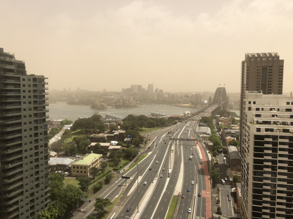
A haze of dust sits over Sydney.
NSW Health Services recommend limiting time outdoors during dust storms. Photo: Tago Fabic
Currently, there’s a line of dust more than 500km long sweeping across the Victorian border, through Canberra and up to Queensland. This dust is more than just annoying – it can be bad for our health, ecosystems, and the built environment.
If you’re being impacted by a dust storm, please take advice from your local authorities for health warnings. NSW.
Video courtesy from BoM, generated using JMA’s Himawari satellite.
The current drought has stripped a lot of ground cover across eastern Australia, leaving wide ranges of dry, exposed dirt that pose an increased dust storm risk. To predict the risks of dust storms, we need to marry weather forecasts with the potential dust sources across the country and see if they are going to meet up.
Few of us could forget the dust storm in September 2009, which famously blanketed Sydney in a bright orange hue. The urban costs of this storm were estimated at $300 million alone.
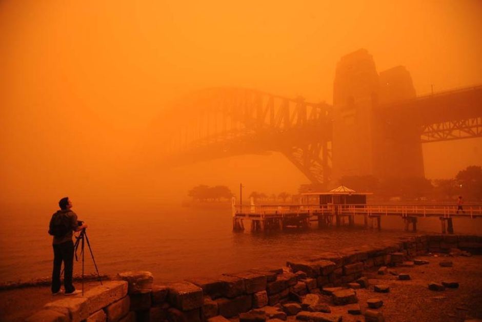
A photographer stands in front of the Sydney Harbor Bridge, both of which are obscured by a red dusty haze.
Red haze enveloped Sydney Harbour Bridge during a dust storm on September 23, 2009. Photo: Amber Hooper
Predicting dust storms
Dr Juan Pablo Guerschman, one of our research scientists, has been working with colleagues in the Australian, state and territory governments to deliver Australia’s dust and ground cover monitoring expertise and is supported by the Australian Government’s National Landcare Programme.
“Using satellite products we can estimate landscape types of interest across the Australian continent, like the proportion of the land that is covered by vegetation – either green or dry – or that is bare soil.”
“When there’s windy weather and low ground cover, it means that there’s a risk of dust storms and erosion of our soil, and so particularly in spring and summer we know that our data products will be in demand.”
Every eight days a new image comes through from a US satellite called MODIS. Juan and his team have developed a system that takes that satellite information, runs it through mathematical calculations and delivers information about groundcover through the Rangeland and Pasture Productivity Map. This is then picked up by data users such as the Community DustWatch program to assess where there might be sources of dust if the wind is strong enough.
The DustWatch program tracks wind erosion across Australia and produces a range of maps and products for use by governments and land managers and to warn agencies monitoring air quality of incoming dust storms.
In many parts of Western NSW, vegetation levels are the lowest they’d been since Juan and his team started capturing images of the cover in 2001. While the lack of vegetation is not as extreme as in 2009, the most arid part of the outback – where most of the dust comes from – is in much lower condition than average, so this event was expected which allowed for some advance warning to impacted communities. You can explore the image here.
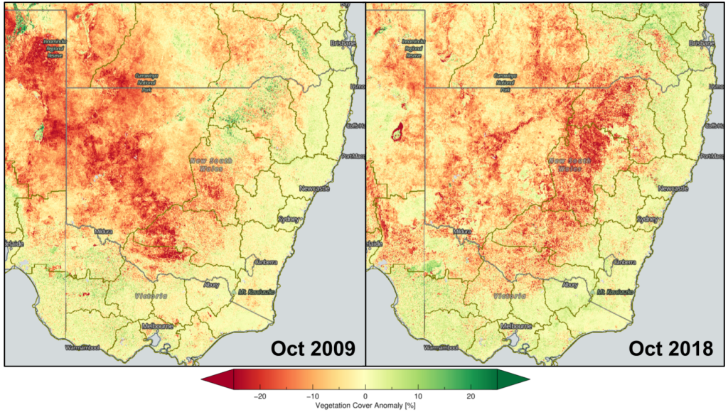
Map of vegetation cover in 2009 vs 2018.
The current conditions aren’t as severe as those from the dust storm of 2009 – but can still cause strife.
Not the ideal white Christmas
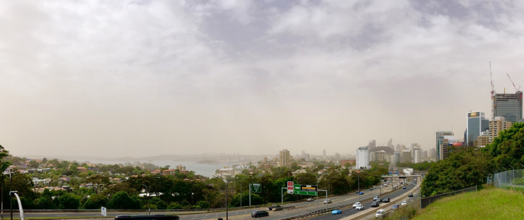
Dust has settled in a blanket over Sydney.
Dust has settled in a blanket over Sydney. Photo: Kenny Smith.
Some additional analysis by the Dustwatch project suggests that the vegetation cover this coming summer may plummet to the low levels observed in previous droughts.
The online tool helps regional NRM organisations, industries and policy makers to inform them of ground cover change, and will provide the basis for Department of Agriculture and Water Resources’ reporting on improvements in resource condition at the national level.
This research can do more than just predict potential dust storms- across the world, researchers can link this land cover information with biomass and animal production models to understand how we can sustainably produce more food.
If you’re being impacted by a dust storm, please take advice from your local authorities for health warnings. NSW.

2nd January 2019 at 4:33 am
On New Year’s Eve 2018 the largest dust storm ever to envelope Western NSW came rolling in at 100kmh. It was immense and spread over hundreds of kilometres from Coonamble down to Condobolin. As I watched it blanket the township of Tottenham and obliterate the sun, I wondered how many more catastrophic events like this we are in for? I would say plenty more because no one has been monitoring land clearing in Western NSW. I pass paddock after paddock where mature trees have been ripped from the ground in readiness for cropping and grazing but there has been no attempt to form wind breaks or clusters of trees to keep the soil in place. Surely there must be some way of stopping this wholesale stripping of the land. We are creating deserts where there once used to be arable land. And yet the land clearing laws don’t seem to do anything to stop these landowners from destroying our planet. Since moving to the Central West, I have developed asthma and I put it down to the dust that is ever-present in the air in this region. Unless the Government does something to stop this raping of our countryside, it’s not only the planet which is going to suffer, but humans too as more and more of us develop serious lung and breathing conditions which could lead to early deaths. I would recommend the responsibility of land clearing be taken away from farmers completely as most have proven they are too brain-dead and irresponsible to make such decisions. There should be Government officials who come out to the property BEFORE one tree is touched and that official determines what trees can go and what trees must stay. Leaving such decisions up to the farmers is insane and if they are left to their own devices they will turn perfectly good farming land into lifeless desert and they what will the people eat, dust??
29th November 2018 at 3:52 pm
Overwhelmed by frustration at our continuing inability to keep our truly fragile country clothed I didn’t stop to read the link to the economists’ Rangeland Journal calculation of $9M a year for NSW, described as a relatively modest annual investment benefitting both rural and urban economies – especially if we continue having two storms in ten years, not the 1 in 50 they assumed. Let’s get on with it!
29th November 2018 at 3:22 pm
$300M in 2009, how much this year? The “urban cost” of dust storms generated from bare ground in our pastoral regions is only part of the cost. How much would it cost to have drought policies, strategies and management that prevent the loss of groundcover in the first place? In 2009 I drove from Brisbane to Broken Hill through the dust being whipped off bare ground with sheep on it.
Yes, we know we have exported dust to NZ long before the sheep arrived (http://www.abc.net.au/science/articles/2007/08/13/2001651.htm), but every bit of veg reduces the severity.
CSIRO’s long history of good research into pastoral land use doesn’t seem to have paid off in land management practice. Time for some serious outback carbon sequestration.